
HABITAT RESTORATION
Please see the CCWG Home Page for a map of our Restoration site locations
Throughout the Salinas Valley much of the historical wetland habitat has been converted to rural and agricultural uses. Much of the runoff from these modified habitats is funneled into created, or highly altered, waterways that are essentially used as drainage ditches to remove excess water. This water often has very high nutrient and pesticide concentrations, which eventually enter the Monterey Bay Sanctuary. Some of the functions that are lost when watersheds are altered include filtration of pollutants, recharge of aquifers, flood storage capacity, and habitat for native flora and fauna. CCWG and partners have worked to restore important habitats throughout the Monterey Bay region for the past 2 decades. Our focus is the restoration and conservation of coastal wetlands, adjacent upland environments, and the natural functionality of watersheds.
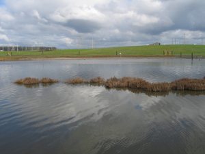
Moro Cojo Slough Management and Enhancement
The ongoing Moro Cojo Slough Project directly targets several environmental and water quality problems identified in the Moro Cojo Slough Management and Enhancement, Northern Salinas Valley Watershed Restoration, and the Central Coast Regional Toxic Hot Spot Cleanup Plans by implementing measures that address the primary goals and objectives of these plans, within the context of an active large-scale agricultural setting. Our specific goals are the enhancement and restoration of the natural resource services of the wetlands, floodplains, and adjacent upland habitats of these watersheds. This includes wildlife habitat, flood control, and mitigation to the impacts of human activities on wetland resources (particularly those that affect water quality). Furthermore, our efforts demonstrate the use and advantages of Best Management Practices (BMPs) for the watershed, while providing natural resource interpretation, educational, and research benefits.
The following are final reports from past grant funded efforts in the Moro Cojo watershed:
- Moro Cojo Slough Management and Enhancement Plan (1996)
- Phase I Moro Cojo Restoration Project (2004)
- Phase II Moro Cojo Restoration Project (2007)
- Restoring Natural Water Systems in the Moro Cojo Slough Watershed (2009)
- Status Report of the latest updates on efforts in the watershed (2013)
To learn about some of the specific projects we have worked on as part of the Moro Cojo restoration, click on these documents to download a PDF about a site:
- Calcagno 1
- Calcagno 2
- Calcagno 3
- Granite Rock
- Moon Glow Dairy Marsh
- Tope Family Property
- Tottino Ponds
- Dolan Farm Boarder
- Castroville Slough Treatment Wetland
- Molera Road Treatment Wetland
- Hugo Tottino Wetland
Current Efforts:
CCWG, in collaboration with Coastal Conservation and Research, received funding from the Ocean Protection Council in 2017 to complete the core objectives of the Moro Cojo Slough Management and Enhancement plan.
Specifically, this project:
- Re-established the Moro Cojo Slough Technical Advisory Committee
- With input from the TAC-
- Established prescriptive guidelines for long term management of the repaired tide gate
- Drafted detailed hydraulic and engineering design plans for the upstream weir to address recent marine impacts to brackish and freshwater areas of the Slough
- Constructed the weir/barrier to tidal flooding (as described in the 1996 Moro Cojo Plan) near the railroad.
- Transferred ownership of the a 35 acre parcel from the landowner (OceanMist Farms) to Elkhorn Slough Foundation
- Restored the 35 acre disced parcel adjacent to the Moro Cojo Slough State Marine Reserve
- Completed a Moro Cojo Slough (including the SMR) long-term management strategy that addresses Sea Level Rise adaptation strategy and long-term tide gate management; submitted to Monterey County and adjacent land owners for consideration of adoption.
Deliverables:
Technical Advisory Committee Documents for OPC-Funded Project (2017-2023)
- TAC Meeting 1
- TAC Announcement, Meeting Notes, Presentation
- Moro Cojo Salinity Summary 2014-2017
- TAC Meeting 2
- Meeting Notes
- Presentation
- TAC Meeting 3
- Meeting Notes, Presentation
- TAC Meeting 4
- Meeting Notes
- Presentation
- Moro Cojo delisting document
- Moro Cojo tidegates, levees pumps KMZ layer
- TAC Meeting 5
- Meeting Notes
- Presentation 1
- Presentation 2
- TAC Meeting 6
- Agenda
- Notes
- Presentation
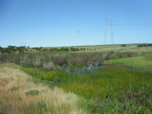
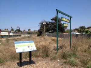
North Monterey County High School Habitat Enhancement
CCWG is working with the North Monterey County School District to develop and implement a restoration plan for a large parcel of land owned by the District immediately adjacent to the High School in Castroville. The area intersects the Upper Moro Cojo Slough, and is known to be home to the endangered Santa Cruz Long-Toed Salamander. With input from partners that include the USFWS, CDFW, the Resource Conservation Districts of Santa Cruz and Monterey County, the Elkhorn Slough Foundation and John Gilcrest & Associates, the design takes into account the needs of the species and the restrictions with working around them, as well as benefiting the students at the school. In August of 2014, the Coastal Conservancy granted some Integrated Watershed Restoration Program funds to begin drafting the plan and in 2016 the restoration was completed.
In 2017 the restoration project was funded by the Wildlife Conservation Board. The project entails enhancing wetland and upland habitat for the long-toed salamanders, while also improving open space access for students and the community through the installation of trails and interpretive signage. Students will participate in the restoration process during planting days as well as aiding in monitoring of the site.
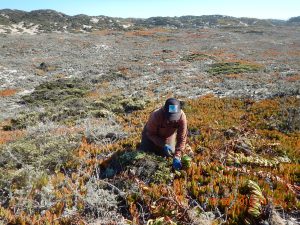
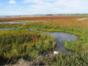
Salinas River State Beach Dune Restoration Project
Recent sea level rise (SLR) hazard maps, created by the State Coastal Conservancy and ESA PWA (2014) for the Monterey Bay Coast, identify sections of the Salinas River State Beach and adjacent dune systems as being highly vulnerable to climate change induced dune and beach erosion and storm induced flooding. A study conducted by the Center for Ocean Solutions (COS) in 2012 also shows this region to be at the highest risk to SLR. Salinas River State Beach (SRSB) and its adjacent dune systems provide a natural ocean barrier to thousands of acres of low lying agricultural and wetlands resources that are protected from winter storms by these dunes. Small breaches in the most vulnerable sections of the SRSB could allow ocean flooding of vast areas of the Salinas Valley. We seek to reduce coastal vulnerability of two breach points in the dune complex by improving the natural adaptive capacity of these coastal dunes. Sand dunes, in their natural state, retard wave run-up erosion and minimizing ocean induced flooding, while providing critical habitat to many special status species. However, the natural dune vegetation at SRSB and its adjacent dunes has been disrupted by the introduction of ice plant (Carpobrotus edulis) and other invasive plants. Ice plant is an invasive species that has choked local dune systems and impacted important physical and ecological dune functions. The documented degradation of foredune habitat by invasive species undermines the dune’s capacity to act as a protective barrier to sea level rise (Jenks et al. 2014). Restoring impacted dune areas identified to be most vulnerable to SLR will not only help restore a unique and sensitive habitat of the Salinas Beach Natural Preserve and rivermouth lagoon, but will also enhance the resiliency of the dune system from the multiple impacts of SLR.
Phase 1: funding provided by the State Coastal Conservancy:
Phase 2: funding provided by the California Department of Fish and Wildlife-Environmental Enhancement Fund:
Santa Rita Creek Restoration
CCWG has been working with the Monterey Bay National Marine Sanctuary, the Resource Conservation District of Monterey County, the Bolsa Knolls Watershed Group, and the Santa Rita Elementary School to improve the Alisal/Tembladero subwatershed. The emphasis of this effort is on reducing polluted runoff from irrigated agriculture and improving the habitat and water quality conditions of both urban and rural stretches of Santa Rita Creek in Salinas, CA. The project is a holistic approach to improving water quality conditions in a watershed with over 60 TMDLs resulting from upstream agricultural practices and urban development. These pollutants are currently left untreated as they flow from the upstream agriculture through this densely populated urban area. This creates a public health risk.
The following efforts have been made towards improvements in this watershed:
- The Coastal Conservancy provided Integrated Watershed Restoration Program (IWRP) funds to develop restoration plans and obtain permits to restore Santa Rita Creek where it runs along Ferrasci Little League field. Plans were completed in 2013 and permits were completed in early 2014.
- Through the Greater Monterey County IRWMP, more funding was provided for the project entitled “Watershed Approach to Water Quality Solutions.” The IRWMP funding allowed CCWG to implement the plans paid for and permitted through IWRP by doing the on‐the‐ground restoration of the creek. Restoration regraded the creek over one key stretch, establish native plants in local landscapes to reduce erosion, improved aquatic habitat and provided aesthetic beauty. In addition to the restoration activities, the Sanctuary will be working with the community and doing water quality analysis, while the RCD works with the surrounding agriculture to reduce upstream inputs of tail water and sediment.
- Link to Restoration Assessment
- Additional funding has been obtained from the Community Foundation of Monterey County to remove invasive plants and plant natives along a stretch of Santa Rita Creek adjacent to the elementary school. CCWG worked with Return of the Natives (CSUMB) to do in-classroom activities, as well as student and community planting days at the site.