Miya Pavlock-McAuliffe
Mini Bio
Miya is a master’s student in Physical Oceanography at Moss Landing Marine Labs, through California State University – Monterey Bay. She is a fellow with NOAA’s Center for Coastal and Marine Ecosystems, a Cooperative Science Center to provide a better understanding of issues confronting coastal and marine communities. Miya’s research is focused on understanding geomorphologic change and the associated hydrodynamic drivers and feedbacks that occur in the coastal zone. Her research utilizes a dual camera Argus station that allows for temporal monitoring of shoreline and sandbar in the northern Monterey Bay of Central California.


Research
Beach morphology in the northern Monterey Bay responds to interannual, seasonal, and storm-scale variations in wave climate. However, the current understanding of morphologic change is based on biannual survey data, obscuring the effects of winter storms. Miya utilized nearly two years of continuous video observations collected every half-hour during daylight hours to build a time series of beach and nearshore morphology at Sunset State Beach.
Results
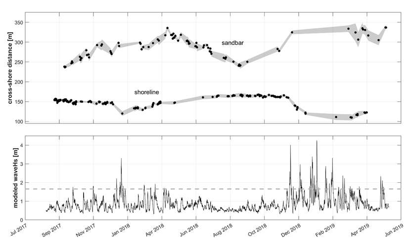
Observations showed that most shoreline erosion occurs following the first large wave event of the winter season, though further erosion or subsequent recovery occurs according to wave characteristics during the rest of the winter. Miya’s work reveals higher coastal variability than previously observed in the northern Monterey Bay and offers insight into the impact of wave forcing and shoreline-sandbar interactions on shoreline change. By parsing apart the processes driving coastal change, we can improve forecasts and inform coastal resilience efforts by providing information to decision makers faster than previously possible with traditional survey methods.
Time series of all imagery mapped shoreline and sandbar positions. In the top panel, black dots represent the alongshore averaged sandbar or shoreline position mapped from imagery and the grey envelope indicates the standard deviation of the 600m stretch of sandbar or shoreline. The envelope is interpolated between observations so does not necessarily represent observed change. The bottom panel shows CDIP MOPs nearshore significant wave height near Sunset State Beach and the dotted line suggests a possible wave energy- shoreline erosion threshold.

To learn more about the camera monitoring technique, visit this USGS Webpage and this one for friendly descriptions!

